Assessment of the Accuracy of Volcanic Hazard Prediction at Soufriere Hills Volcano, Montserrat, West Indies for the 1995-Present Eruption
S.E. Clifford, April 1997
Abstract: Soufriere Hills Volcano is the youngest of four volcanic complexes on the island of Montserrat in the Lesser Antilles. It had not been seen to erupt until 1995, but the geologic record indicates a history primarily consisting of andesitic dome-building, pyroclastic flows, and mud flows. Studies from 1980s focused on predicting the hazards from future eruptions, including the directions taken by pyroclastic flows and mud flows, the explosivity of the eruption, and the likelihood and severity of tephra fallout. All studies indicated that the worst damage would most likely occur on the eastern side of the volcano where the wall of the summit caldera has slid away, and that future eruptions would be similar in character to past ones.
An eruption of the volcano beginning in July, 1995, and still continuing has provided a chance to test these predictions. The development of the eruption has proceeded largely as predicted, with some notable exceptions. Early phreatic explosions and a later magmatic explosion produced much more tephra fall than expected, and the models did not predict the potential for failure of other segments of the caldera walls. The worst damage has primarily confined to the forecasted areas. The volcano currently shows no signs of decreasing activity.
Introduction:
The eruption of the Soufriere Hills Volcano on Montserrat in the northern Lesser Antilles, beginning in July 1995 and continuing to the present, has provided a rare opportunity to test volcanologists’ ability to predict volcanic hazards based on geological evidence for a volcano with no previously observed eruptions. Studies done in the 1980s based on the deposits of prehistoric eruptions and the topography of the island attempted to classify the types of activity that could possibly be expected from this volcano and the regions most likely to be affected. The activity that has taken place during the current eruption, the first known since the settlement of the island, can now be compared to the predictions, and the methods used to arrive at them thereby evaluated.
Geologic setting:
Soufriere Hills is the youngest of four main volcanic complexes on the island of Montserrat, having grown on the northern slopes of South Soufriere Hills Volcano in the southern half of the island. The older complexes of Silver Hill and Center Hills occupy the northern half of the island. The majority of previous activity at Soufriere Hills took place from 24-16 ka, covering its flanks with pyroclastic flows and mudflows. The upper ramparts of the volcano consist of “a series of five central andesitic lava domes: Gage’s Mt., Chance’s Mt., Galway’s Mt., Perche’s Mt., and Castle Peak” (Wadge and Isaacs, 1988, p. 541). Castle Peak occupies English’s Crater, which has walls 100-150 m high in a 1 km-wide horseshoe open to the ENE. These domes, along with the parasitic centers at St. George Hill and Garibaldi Hill to the WNW and Roche’s Bluff to the ESE, define a zone trending WNW which may indicate a zone of crustal weakness at depth that formed an upward path for the magmas erupted at Soufriere Hills Volcano. This zone is considered the most likely area for future eruptions (Wadge and Isaacs, 1988, p. 541).
The five main lava domes are steep-sided andesitic structures surrounded by low-profile aprons of pyroclastic deposits consisting primarily of andesitic block-and-ash flow surge deposits and mud flow deposits. Some of the domes are truncated by English’s Crater, the source of a debris avalanche which produced the hummocky terrain of the Tar River-Spring Ghaut area on the eastern flanks of the volcano. The youngest dome, Castle Peak, has two summit pinnacles most likely representing extrusive spines. These observations indicate a scenario similar to the 1902 eruption of Mt. Pelée on Martinique, in which the formation of andesitic lava domes was accompanied by explosions which partly destroyed the domes and produced pyroclastic flows (Chiodini et al., 1996, p. 391).
Three times in the century preceeding the eruption there have been volcano-seismic crises beneath the southern part of the island, each accompanied by an increase in fumarolic activity. The first, from 1897-1898, is poorly known. Between 1933 and 1937 most of the earthquake foci were probably located 1-2 km beneath Soufriere Hills and St. George Hill. In the 1966-1967 crisis, “the mean depth of hypocenters decreased from 5.2 to 2.8 km and increased afterwards” during the first 9 months (Chiodini et al., 1996, p. 391). This is interpreted as the result of magma rising to within 4-5 km of the surface beneath Soufriere Hills Volcano in 1966-1967, and probably during the other crises as well (Wadge and Isaacs, 1988, p. 545).
Volcanic hazard assessments prior to the eruption:
Baker (1985, p. 292) notes that prior to the formation of English’s Crater, most of the pyroclastic flows from prehistoric eruptions discharged toward the western side of the island and the present location of the capital, Plymouth. The opening of the crater to the east, however, altered the preferred direction of flow away from this population center, as shown by the location of the youngest deposits in the Tar River area. Baker’s map of the relative pyroclastic flow hazards for southern Montserrat (Figure 1) depicts radial hazard zones around the volcano, with the greatest hazard being directly east of English’s Crater and the next greatest occupying two zones: one to the NE of the volcano around Tuitt’s Ghaut (also called White’s Bottom Ghaut), the other directly to the west and containing Plymouth.
Figure 1: Baker, 1985, p. 293
Baker also points out that Soufriere Hills Volcano has no history of lava flows and very scant record of pyroclastic falls, and assesses these hazards to be minimal in future eruptions. Prevailing low-level winds would most likely deposit the bulk of any pyroclastic fall to the west between Plymouth and Old Fort Point. More significant dangers would be posed by mud flows and flash floods associated with pyroclastic flows, which are well represented in the geologic record on Montserrat. One additional hazard may be posed by the development of parasitic centers such as St. George Hill, where most of the deposits are of andesitic pumice, in unpredictable locations.
Wadge and Isaacs (1988) produced hazard maps of the island based on computer modeling of eruptions which closely match the geologic evidence from Montserrat and evidence from observed eruptions of similar character. This allowed them to produce more detailed and spatially precise maps of hazard zones than those like Baker’s based on traditional methods.
Wadge and Isaacs predicted that the next major eruption would involve the formation of an andesite summit dome and the explosive discharge of pyroclastic flows, with the vent most likely occurring in a zone defined by the centers of the four older domes and English’s Crater, which contains the highest probability. They expected the eruption to develop in three stages based on observed eruptions from similar volcanoes, beginning with small initial phreatic or phreatomagmatic explosive eruptions. The second stage would involve major explosive activity, pyroclastic flows, and dome-building over the vent. The third stage would consist of mostly quiet dome growth and occasional pyroclastic flows gradually diminishing over months to years.
Two variations on this eruption development sequence are presented: first, that the eruption may not develop beyond the first stage, and second, that the second stage may involve lateral blasts. Although evidence of this second possibility, such as coarse ballistic fragments, has not been identified at this volcano, it is conceivable that English’s Crater is the remnant of such an eruption, but much of the depositional evidence would be underwater to the east of the island, so this hazard is not considered further.
Wadge and Isaacs agree with Baker that the preferential direction of flow at Soufriere Hills Volcano is east out of the opening of English’s Crater. They point out, however, that the Crater walls are fairly low and could be overtopped by a sufficiently energetic eruption with a high eruption column. Generation of mud flows could be produced either by heavy rainfall mobilizing pyroclastic debris in the existing drainage systems or by the expulsion of large volumes of hot groundwater from fumaroles, which could affect other parts of the volcano.
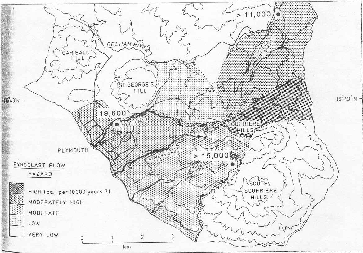
The computer-generated hazard map (Figure 2) produced by Wadge and Isaacs incorporates models of eruptions with a variety of energy levels and different vent sites to define hazard zones which are more concentric around the volcano than those shown by Baker. Again, the greatest hazard from an eruption centered at Castle Peak Dome is shown for the Tar River area east of the volcano, but this time with arms radiating outward from the summit down the major stream valleys. Other zones indicate the areas at risk from eruptions increasing in strength incrementally. Wadge and Isaacs conclude that low-energy eruptions would not directly threaten any community with pyroclastic flows, and the most energetic eruptions considered have no support in the geologic record and have probably not occurred in the past.

Figure 2: Wadge and Isaacs, 1988, p. 549
The 1995-present eruption:
The current eruption of Soufriere Hills Volcano was preceded in 1992 and 1994 by swarms of earthquakes under southern Montserrat. The following chronology of the eruption through September 1996 is taken from the Government of Montserrat and Montserrat Volcano Observatory web site.
The eruption began on 18 July, 1995 with steam and ash venting from the northwestern part of English’s Crater. More vents opened up on 28 Jul, and 20, 22, and 28 August with small amounts of ash and vigorous steaming. The first large phreatic eruption occurred on 21 Aug, blanketing Plymouth in a thick ash cloud and causing 15 minutes of darkness. Southern Montserrat was evacuated for the first time shortly afterwards.
Initial signs of dome formation in English’s Crater appeared in late September, 1995, along with a small spine in the SW part of the Crater. The first mud flow came from the SE side of the Crater on 17 October, followed by another large phreatic eruption 13 days later. On 14 November the first signs of new dome growth were seen in the 18 July vent, and quiet dome growth with occasional earthquake swarms and slow deformation of the volcano continued until late March, 1996.
On 29 Mar the first block and ash flows descended from the Crater region into the upper Tar River valley, followed by the first pyroclastic flow in the same direction on 3 April. Collapse of the eastern face of the dome caused additional pyroclastic flows on 6 and 8 Apr, and on 12 May the “Mother’s Day” pyroclastic flows reached the sea. Dome growth during May was concentrated in the NE sector of the Crater, but switched to the NW on 9 June, subsequently overtopping Gage’s Wall before moving again to the N and SW sectors. On 20 Jul seismic activity increased, accompanied by a major increase in the rate of magma production to 10 m3/s by 25 Jul, leading to major collapses and pyroclastic flows into the Tar River valley. Dome collapses and pyroclastic flows continued through early September.
On 17 September, 1996, a series of dome collapses led to the first magmatic explosion close to midnight. Rocks and pumice fell over the southern part of the island, and meter-scale impact craters, downed power lines, and burning buildings were observed at Long Ground, where inhabitants described the buildings being “pushed” as if by the impact of a very strong wind. A major ash plume rose to approximately 14 km, producing tephra fall over most of the southern half of the island, estimated at 600,000 tonnes. Several civilian aircraft flying west of Montserrat encountered the plume in the hours after the explosion, and satellite imagery indicated two separate ash clouds, the higher one moving east at 40 knots and the lower and much thicker one moving west at 15 knots. Significant ash-fall was evident in Plymouth, and building fires in many places indicated high temperatures for the falling blocks. Approximately 25 to 30% of the dome had been removed and the Tar River valley was completely stripped of vegetation as pyroclastic flows formed a growing fan at the mouth of the Tar River (Govt. of Montserrat web site, 1997).
Dome growth resumed at the base of the explosion scar on 1 October. In November and December dome growth continued, approaching the top of the Crater and piling up talus against the SW wall, known as Galway’s Wall. Vertical cracks began to extend down the face of the wall and it began to show signs of considerable weakening. On 27 Nov, a large rockfall dislodged ~150,000 m3 of material from the wall and some small pyroclastic flows were generated. Heavy rains that night generated lahars in the Tar River valley and the White River. Avalanches from Galway’s Wall continued into December as cracks quickly expanded. Early reports from 1997 indicate that the lava dome is now larger than it has ever been and appears above the edges of the Crater as the magma extrusion rate continues to remain high (sustained 4.4 m3/s in early Jan). There have not been any reports of wall collapse so far (Global Volcanism Program web site, 1997).
Conclusions:
The development of the eruption of Soufriere Hills Volcano up to early 1997 has followed predictions fairly closely. The eruption began with phreatic explosions and has involved significant dome growth and pyroclastic flow generation throughout the last two years. Most of the damage has been concentrated to the east of the volcano in the Tar River valley below the opening of English’s Crater. The explosivity of the eruption seems to have exceeded expectations, however, and widespread heavy tephra fall in the southern part of the island has occurred despite predictions that this was very unlikely. Baker’s observation on the westward distribution of ash by the prevailing winds appears to be true. Mud flows have not been reported as major hazards to populated areas up to this point, but they have occurred. Although dome growth has shifted positions around English’s Crater, no parasitic centers have developed yet. Niether study predicted the possibility of crater wall collapse, which could redirect many pyroclastic flows and considerably alter the locations of volcanic hazard zones around the island.
Overall, the methods used to predict the hazards posed by Soufriere Hills Volcano have been accurate enough to be of great use to the people of Montserrat. The eastern side of the island has been vacated since virtually the beginning of the eruption, and several shorter-term evacuations have been successfully organized in Plymouth and other communities since then. The second stage of the eruption, however, does not appear to be over, and several surprises have already occurred, so this test is far from over.
References:
Baker, P. E. (1985) Volcanic hazards on St. Kitts and Montserrat, West Indies. Journal of the Geological Society of London, Vol. 142, p. 279-295.
Chiodini, G., Cioni, R., Frullani, A., Guidi, M., Marini, L., Prati, F., and Raco, B. (1996) Fluid geochemistry of Montserrat Island, West Indies. Bulletin of Volcanology, Vol. 58, p. 380-392.
Dolan, M. (1997) The Government of Montserrat and
Montserrat Volcano Observatory web site.
URL: http://www.geo.mtu.edu/volcanoes/west.indies/soufriere/govt/
Smithsonian Institution. Global Volcanism Network
Bulletin Reports for Soufriere Hills, on web site of Global Volcanism Program,
National Museum of Natural History.
URL: http//www.volcano.si.edu/gvp/volcano/region16/soufhill/gvnb.htm#21
Wadge, G., and Isaacs, M. C. (1988) Mapping the volcanic hazards from Soufriere Hills Volcano, Montserrat, West Indies using an image processor. Journal of the Geological Society of London, Vol. 145, p. 541-551.